

RTK GNSS Survey on Oman Solar Projects: Desert Field Guide 2026
- Oman's Solar Energy Pipeline: Scale and Survey Demand
- GNSS Survey Requirements on Utility-Scale Solar
- The Desert Survey Challenge
- Why Base+Rover, Not CORS
- Field Setup: MAX5 Base + AP40 Laser+ Rover
- Pile Foundation Stakeout Workflow
- Cable Corridor and Access Road Survey
- Operating RTK in 45°C Desert Conditions
- FAQ
Oman is in the middle of one of the Gulf region's most ambitious renewable energy buildouts. The 93 MW O-Green Suhar Solar Project — spanning 1.45 million square metres and comprising approximately 150,000 solar panels in Suhar Industrial City — is one of the largest captive industrial solar installations in the region. The 500 MW Ibri III Solar IPP, developed by a Masdar-led consortium in the Al Dhahirah Governorate, integrates utility-scale photovoltaic generation with a 100 MWh battery energy storage system. The ACME Duqm project scales further still — 3.5 GW of solar and 500 MW of wind across a 92 km² land block, producing green hydrogen and ammonia for export. Every one of these projects requires precision GNSS survey: for pile foundation stakeout, topographic mapping, cable corridor alignment, substation layout, and access road setting-out. This is where APEKS RTK equipment is deployed.
Oman's Solar Energy Pipeline: Scale and Survey Demand
Oman's Vision 2040 renewable energy targets are driving the fastest expansion of utility-scale solar capacity in the Gulf. Three major project types define the current pipeline — and each generates distinct GNSS survey workloads.
Captive industrial solar (Suhar model): The O-Green Suhar Solar Project delivers 93 MW directly to over 200 industrial facilities in Suhar Industrial City under a captive power supply model. At 1.45 million square metres, this single installation requires survey for approximately 150,000 pile positions, the internal cable routing network, access roads, and substation and inverter pad locations. Stakeout accuracy requirements for solar pile foundations are typically ±20–50 mm — achievable with RTK in Fixed solution.
Utility-scale IPP (Ibri model): The Ibri III Solar IPP at 500 MW PV coupled with 100 MWh battery storage requires control network establishment, large-area topographic survey for panel tilt optimisation and drainage design, tracker foundation stakeout across the full site, and as-built documentation for the battery storage facility. At this scale, a single survey team with RTK can complete pile stakeout at 200–400 positions per day — far exceeding what a total station crew could achieve across the same area.
Mega-project industrial zones (Duqm model): The ACME Duqm project at 92 km² requires survey across terrain equivalent to a medium-sized city. At this scale, multiple base stations are deployed to provide correction coverage across the project area simultaneously, with rover teams working in parallel across different sectors.
GNSS Survey Requirements on Utility-Scale Solar
Utility-scale solar construction generates five distinct GNSS survey workloads, each with specific accuracy and workflow requirements.
1. Pre-construction topographic survey: A full terrain model of the site is required before design finalisation — for panel tilt angle optimisation, drainage channel design, access road gradients, and cut-and-fill earthworks calculation. RTK picks up thousands of ground points per day. Accuracy requirement: ±50 mm vertical, sufficient for earthworks design.
2. Pile foundation stakeout: Each solar panel row sits on driven or screw-anchored piles. On a 150,000-panel installation like Suhar, the pile grid can require 30,000–60,000 individual stakeout positions. Each pile position must be marked to ±20–50 mm horizontal accuracy to ensure tracker alignment and row spacing. This is the highest-volume survey task on any utility-scale solar project.
3. Cable corridor alignment: DC string cables and AC feeder cables must follow precise corridors between panel arrays, inverters, and the substation. Cable trench alignment survey marks the centre line and depth references for the trenching crew.
4. Substation and inverter pad layout: Electrical infrastructure — inverter skid pads, transformer bays, and the grid connection substation — requires structural stakeout to ±10–20 mm. These are the highest-accuracy stakeout requirements on site.
5. As-built documentation: After construction, as-built survey documents the actual installed pile positions, cable routes, and infrastructure locations against the design for handover and O&M records.
The Desert Survey Challenge
The challenge: Oman's interior desert — where Ibri, Duqm, and many solar project sites are located — experiences summer ambient temperatures regularly exceeding 45°C. Direct sun exposure on a receiver raises its surface temperature beyond ambient. Receivers with operating temperature ratings below +60°C can trigger thermal shutdowns during afternoon summer sessions.
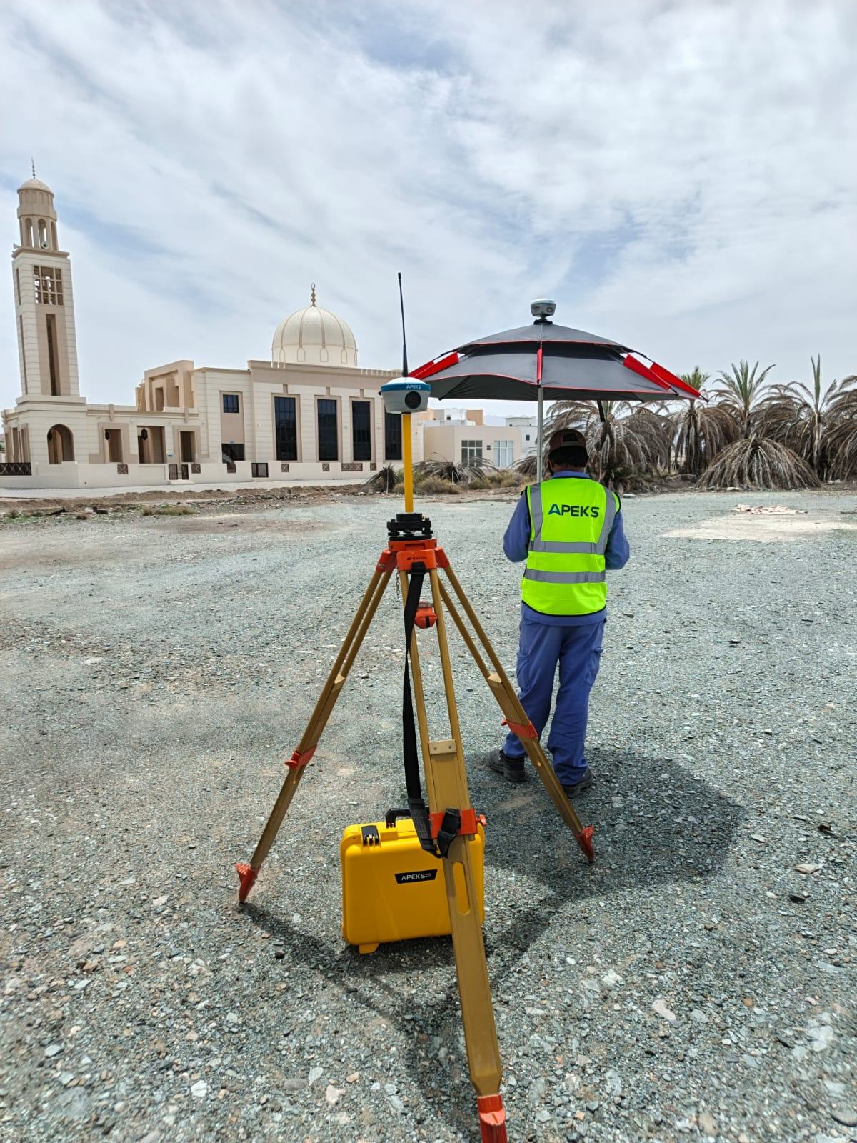
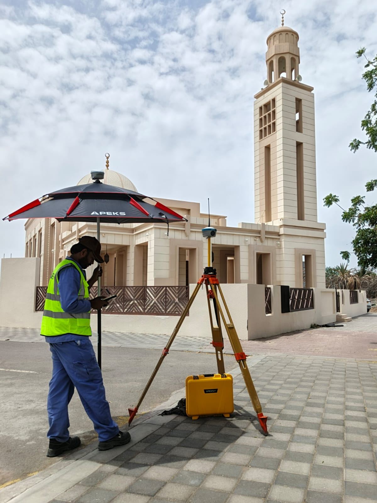
APEKS solution: All APEKS receivers are rated to +75°C operating temperature — one of the highest in the segment. The AP40 Laser+ and MAX5 operate continuously through Oman's peak summer conditions. In the field, survey teams use APEKS survey umbrellas over the MAX5 base station during all-day desert operations — shading the instrument from direct solar radiation while allowing continuous UHF/LoRa transmission. Precision survey sessions are scheduled for early morning (06:00–10:00) when temperatures are lowest and ionospheric activity is minimal.
The challenge: Solar project sites in Oman are typically flat, featureless desert terrain — which is ideal for satellite visibility but creates challenges for base station radio coverage across large areas. The flat ground plane means UHF radio signals travel line-of-sight with minimal obstruction, but antenna height above ground becomes critical for maximum range.
APEKS solution: The MAX5 base station is elevated on a 2-metre tripod at the highest accessible point of the project site — maximising UHF/LoRa radio range across the flat terrain. At 5W LoRa output, the MAX5 achieves reliable correction broadcast to 25 km across open flat desert — sufficient to cover the entire Suhar (1.45 km²) or Ibri III project footprint from a single base position.
The challenge: Oman's national CORS network provides reasonable coverage in Muscat and major urban centres, but Duqm, the Al Dhahirah Governorate (Ibri), and remote coastal industrial zones have limited or no reliable CORS coverage. Single-rover RTK via NTRIP is not a reliable primary method for these remote project sites.
APEKS solution: Base+Rover 1+1 deployment eliminates the CORS dependency entirely. The MAX5 base station establishes its position via averaging or on a known control point, then broadcasts corrections directly to the AP40 Laser+ rover via UHF/LoRa radio. No internet, no SIM card required for the correction link — the system is completely self-contained regardless of cellular network coverage at the project site.
Why Base+Rover, Not CORS
For Oman's remote solar project sites, the Base+Rover 1+1 model is the standard operating configuration — not a fallback for when CORS fails. The reasons are straightforward.
CORS coverage is insufficient: The nearest CORS reference station to Duqm is hundreds of kilometres away. Baselines of this length prevent reliable RTK Fixed resolution — atmospheric decorrelation at long baselines degrades accuracy to sub-metre levels, unacceptable for pile stakeout.
Cellular data is unreliable: Remote desert construction sites in Oman often have marginal or no cellular data coverage. NTRIP correction streams require a stable 4G connection with differential age below 3 seconds — not achievable on sites beyond cellular range.
Base+Rover is more accurate at short baselines: A local base station 2–5 km from the rover produces a shorter baseline than any CORS station. Shorter baseline means lower atmospheric decorrelation and faster, more reliable Fixed solution — particularly important when re-initialising after brief obstructions from construction vehicles or equipment.
No recurring costs: A Base+Rover deployment requires no CORS subscription fees. On a 12-month solar construction project with multiple receiver teams, eliminating annual CORS fees represents meaningful cost savings.
Field Setup: MAX5 Base + AP40 Laser+ Rover

Set up the MAX5 on a 2-metre aluminium tripod over a known GNSS control monument established from Oman's national geodetic network (WGS84/ITRF). Level and centre the instrument. The MAX5's 1.39" OLED touchscreen confirms base mode, satellite count, and radio transmission status directly on the instrument — no controller connection required to verify base operation.
Attach the APEKS survey umbrella to the tripod to shade the MAX5 from direct solar radiation during all-day sessions. The umbrella reduces the instrument's surface temperature by 10–15°C in direct Omani summer sun — extending continuous operation without thermal management concerns.
In ApekSurv, set the MAX5 to Base mode. Select UHF channel and LoRa protocol to match the AP40 Laser+ rover configuration. The MAX5's 13,200 mAh battery provides 8+ hours of continuous base operation — a full solar construction working day without battery change.
Set the AP40 Laser+ to Rover mode with the matching UHF channel. Confirm Fixed solution achieved — typically within 10–30 seconds of entering the correction range on open desert terrain. Verify against a known control point before beginning stakeout.
Import the pile grid CSV file exported from the project design software. Verify coordinate system matches the project datum. Group pile positions by construction sector or row number to organise the stakeout sequence by work area.
A single operator with the AP40 Laser+ navigates to each pile position using ApekSurv's directional arrow, marks the position with a pin or spray paint, records the as-staked coordinate for QA documentation, and moves to the next position. On flat open desert terrain, experienced operators achieve 200–400 pile positions per day.
Pile Foundation Stakeout Workflow
Pile foundation stakeout is the dominant survey task on utility-scale solar construction sites by volume. On a project like Suhar with ~150,000 panels, the pile grid can exceed 40,000 individual pile positions — each requiring a physical ground mark that the civil crew uses to drive or drill the foundation element.
Accuracy requirement: Solar tracker pile foundations typically require ±20–50 mm horizontal stakeout accuracy. RTK in Fixed solution delivers ±8–15 mm — well within tolerance, with margin for the physical marking operation. Higher-accuracy requirements (±10 mm) apply to inverter pads and substation infrastructure where structural connections depend on precise anchor bolt positions.
IMU tilt advantage on solar sites: Solar pile grids are laid out across flat desert terrain, but the ground surface is often irregular — compacted gravel, sandy patches, and construction vehicle tracks create uneven footing. The AP40 Laser+'s 120° calibration-free IMU allows accurate stakeout without levelling the pole bubble on every position — the operator plants the pole tip at the design position and records immediately, regardless of pole angle. This eliminates the 5–10 seconds per point that pole levelling would otherwise add — significant across tens of thousands of positions.
QA documentation: ApekSurv records the as-staked coordinate, the offset from design, and the solution status for every recorded position. This produces a complete stakeout QA report for the project engineer — demonstrating that each pile position was marked within tolerance before the civil crew began driving.
Cable Corridor and Access Road Survey
Beyond pile stakeout, two additional survey tasks require RTK on utility-scale solar projects: cable corridor alignment and access road setting-out.
DC string cable corridors: DC cables connect solar panels in strings to string inverters, then to central inverters or combiner boxes. The cable trench must follow a precise alignment between panel rows — typically 1–2 metres wide, excavated to 800–1200 mm depth. RTK marks the trench centreline at 10–20 metre intervals, giving the excavator operator a clear line to follow. The AP40 Laser+'s green laser allows measurement of trench alignment relative to panel row infrastructure without the operator entering the trench.
AC feeder cable routes: AC cables from inverters to the substation follow designed corridors that must avoid panel foundations and access roads. RTK alignment survey marks these corridors before cable laying begins.
Access road layout: Construction access roads across the solar site must be positioned to provide vehicle access to every row without obstructing panel operation. Road centreline stakeout, cut and fill grade stakes, and compaction check survey are all standard RTK tasks on large solar sites. The AP40 Laser+ with 120° IMU handles slope stake setting on road embankments without requiring the operator to access the slope face.
Operating RTK in 45°C Desert Conditions
Oman's desert sites present specific operational considerations that differ from temperate-climate survey environments. Survey teams on Omani solar projects apply the following standard practices.
Session scheduling: Precision stakeout — pile positions, structural pads, substation layout — is scheduled for early morning (06:00–10:00) when ambient temperature is lowest and ionospheric activity is at its daily minimum. Topographic pickup and cable corridor alignment, which require lower precision, can continue through the morning. Afternoon sessions in summer are reduced or avoided for precision work.
Equipment shading: The MAX5 base station is shaded with the APEKS survey umbrella throughout all-day sessions. The AP40 Laser+ rover is kept in a shaded carry case when not in active use between measurement sequences. Both instruments' +75°C operating temperature rating provides substantial thermal margin above Oman's ambient conditions.
Battery management: The MAX5's 13,200 mAh battery provides a full 8-hour base session. The AP40 Laser+'s 7,000 mAh battery provides 18 hours of rover operation — effectively unlimited for a desert working day. Spare batteries are carried but rarely needed for a standard session.
Ionospheric monitoring: Oman's low latitude means higher ionospheric activity than European survey environments, particularly during solar maximum (2025–2026). For cadastral or structural stakeout requiring the highest accuracy, teams monitor the Kp index and schedule precision work for low-activity windows. For standard pile stakeout at ±50 mm tolerance, ionospheric effects at the short baselines used in Base+Rover deployment are not a significant factor.
FAQ
What RTK accuracy is required for solar pile foundation stakeout?
Solar tracker pile foundations typically require ±20–50 mm horizontal stakeout accuracy — determined by the tracker alignment tolerance and row spacing requirements specified by the tracker manufacturer. RTK in Fixed solution delivers ±8–15 mm, providing substantial margin within this tolerance. Higher accuracy requirements of ±10–20 mm apply to inverter skid pads, transformer bays, and substation structural elements where anchor bolt positions must match pre-fabricated equipment layouts precisely.
How many pile positions can one RTK operator stake out per day on a solar site?
On flat open desert terrain with a well-organised pile grid CSV loaded into ApekSurv, an experienced operator with the AP40 Laser+ can complete 200–400 pile stakeout positions per working day. The actual rate depends on pile spacing, walking distances between positions, ground surface condition, and whether QA photography is required at each position. The 120° IMU eliminates bubble levelling time at each point, which contributes significantly to the daily throughput on high-volume pile stakeout.
Can CORS networks be used for RTK survey on Oman's remote solar sites?
For solar projects in and around Muscat, CORS coverage from Oman's national network may be adequate. For remote interior sites — Ibri (Al Dhahirah Governorate), Duqm (Al Wusta Governorate), and other locations away from major urban centres — CORS coverage is typically insufficient for reliable RTK Fixed resolution. The combination of long baselines and marginal cellular data coverage at these sites makes Base+Rover the standard operating method. The APEKS MAX5 base station with 5W LoRa radio provides centimetre-accurate corrections across the full project footprint without any internet or CORS dependency.
How does the survey umbrella help — is it just for comfort?
The survey umbrella on the MAX5 base station is primarily for instrument protection, not operator comfort. Direct solar radiation on a black or dark-coloured instrument casing can raise the instrument surface temperature 15–25°C above ambient — pushing a receiver's internal temperature toward or beyond its rated limit in peak Omani summer. Shading the MAX5 keeps its operating temperature within a safe range throughout all-day desert sessions, ensuring continuous and stable correction broadcast without thermal shutdowns or measurement instability. The umbrella also protects connector seals from UV degradation over multi-month field deployments.
What coordinate system is used for solar project survey in Oman?
Most Omani infrastructure projects, including utility-scale solar, use WGS84 with UTM Zone 40N as the project coordinate system — straightforward for international EPC contractors and compatible with most engineering design software defaults. Some projects specify the Oman National Survey datum (OMAN_GRID) for integration with national cadastral and mapping data. Always confirm the project coordinate system with the engineer before establishing control — the difference between WGS84 UTM and Oman national grid requires a datum transformation if mixed without correction. All APEKS receivers include both systems in the pre-loaded coordinate library.
BUILT FOR OMAN. READY FOR ANY DESERT PROJECT.
APEKS MAX5 + AP40 Laser+ delivers centimetre-accurate pile stakeout, cable corridor alignment, and topographic survey across Oman's utility-scale solar projects — operating at +75°C, with 5W LoRa correction broadcast to 25 km, and no CORS or internet dependency on remote desert sites.
View APEKS RTK Receivers →References
- O-Green Suhar Solar Project — Madayn / Public Establishment for Industrial Estates, Oman
- Ibri III Solar IPP — Masdar / KOMIPO / OQ Alternative Energy, Al Dhahirah Governorate
- ACME Duqm Green Hydrogen Project — ACME Group / Port of Duqm, Oman
- ISO 17123-8:2015 — Field Procedures for GNSS RTK
- APEKS AP40 Laser+ Technical Datasheet, 2026
- APEKS MAX5 Base Station Datasheet, 2026
- ApekSurv Field Software User Guide, 2026